What Is a Haboob Dust Storm and How Does It Form?
A haboob is a towering wall of dust driven ahead of a collapsing thunderstorm. Here is how downdrafts build it, where it strikes, and why drivers fear it most.
Key takeaways
- A haboob is a wall of dust pushed along the ground by the cold outflow of a collapsing thunderstorm, not by ordinary desert wind.
- Its leading edge, the gust front, can be several miles long and thousands of feet high, with dust reaching about 5,000 feet.
- Haboobs are most famous in Arizona's summer monsoon season and in Sudan, where the name originated, but they strike deserts worldwide.
- Visibility can fall to near zero in seconds, so the safest response on the road is to pull completely off the roadway and wait it out.
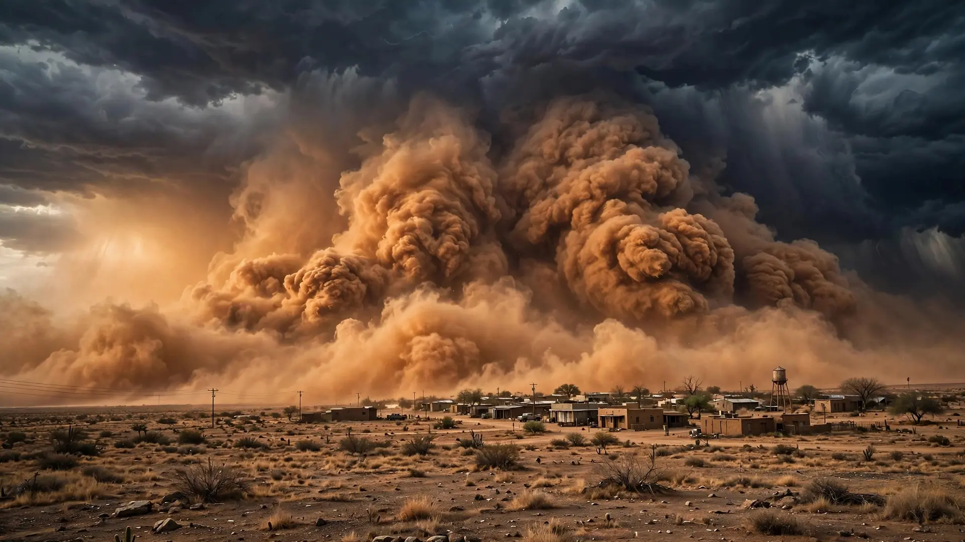
Picture a clear desert afternoon. On the horizon, a strange orange wall rises, solid as a cliff, and races toward you faster than any cloud has a right to move. Within minutes the sky turns the color of rust, daylight dims to a brown gloom, and the wind begins to sandblast everything in its path. You have just met a haboob: a towering wall of dust driven along the ground by a dying thunderstorm. It is one of the desert's most dramatic sights, and one of its most dangerous, because the danger arrives not with the storm's rain but ahead of it.
How does a haboob form?
A haboob begins with a thunderstorm falling apart. While a storm is strong, warm air rushes upward inside it, and rain forms high above the ground. As that rain falls, it drags cold air down with it in a plunging column called a downdraft. Small, intense versions of these downdrafts are called microbursts: bursts less than about 4 kilometers across that last only five to ten minutes, with winds that can sometimes exceed 100 miles per hour. In dry desert air, the falling rain may even evaporate before it reaches the ground, so the storm's collapse can arrive as wind alone, with no rain to warn of it. When the downdraft slams into the desert floor, it has nowhere to go but outward. The cold, dense air spreads across the surface in all directions, like water splashing outward when a bucket is dropped. The leading edge of this surge is called the gust front or outflow boundary, and it acts like a plow. It scoops up loose dust, sand and dry soil and piles the material upward into a dense, rolling wall that advances ahead of the storm. This is what makes a haboob different from an ordinary dust storm: ordinary dust storms can be raised by cold fronts or other strong winds, but a haboob is specifically the dust wall born from thunderstorm outflow. The U.S. National Oceanic and Atmospheric Administration's severe-storms laboratory defines it in exactly those terms, as a wall of dust pushed out along the ground from a thunderstorm downdraft at high speed. The ground itself matters as much as the storm. A haboob needs loose, dry material to lift, so bare soil, fallow fields and sparsely vegetated desert are ideal. Wet ground or thick plant cover holds dust down, while drought and bare earth let the outflow gather a far heavier load. That is why the same storm can produce a spectacular wall over open desert and almost nothing over irrigated land a few miles away.
How big and fast can a haboob get?
Haboobs are built on a scale that is hard to grasp until one swallows a city. They can stretch several miles long, rise several thousand feet high, and travel hundreds of miles from the storm that spawned them. Dust lofted by the outflow can reach heights around 5,000 feet, and the wall itself can extend up to about 100 miles wide. The downdrafts that start the process can strike the ground at 50 to 80 miles per hour, and the wall then surges forward, driven by the cold air behind it. Seen from a satellite, a large haboob looks like a rust-colored tide rolling across the landscape. Seen from the ground, the experience is stranger. The wall approaches as a distinct, churning front, darker at its base and billowing at its top, and then the world inside it turns orange and dim. Strong winds inside the dust can howl for the better part of an hour, though the thickest dust often passes more quickly. After the front moves through, fine dust can hang in the air long after the wind eases, coating cars, houses and lungs with a gritty film.
Where do haboobs happen?
The name comes from Arabic, from a word meaning wind or to blow, and it was originally the name for dust storms in the northern part of Sudan, where hot, dry conditions and powerful storms produce them regularly. Today the word is used for the same phenomenon wherever it appears, and deserts around the world produce them: the Sahara, the Arabian Peninsula, the deserts of Australia and the American Southwest. In the United States, haboobs are most strongly associated with Arizona, especially the Phoenix area during the summer monsoon season. There, afternoon thunderstorms build over the surrounding mountains and desert, then collapse and send their outflow racing across the flat valley floor toward the city. Phoenix residents have watched walls of dust swallow the skyline whole, most recently in a major August 2025 event that engulfed the metro area. Similar storms strike across the Southwest and the High Plains, anywhere a thunderstorm can collapse over dry, dusty ground. The same restless desert air that bends light into mirages and fata morgana can, a few hours later, raise a wall of dust instead.
Why are haboobs so dangerous?
The greatest danger is the sudden loss of sight. Inside a haboob, visibility can drop to near zero in seconds, turning a highway into a blind corridor where drivers cannot see lane markings, brake lights or stopped vehicles. That is how dust storms cause some of their worst crashes: multi-vehicle pileups happen when drivers plow into a wall of dust at full speed, or when one stopped car is struck by the next vehicle that cannot see it. Smaller, fast-moving dust channels along highways can be even more treacherous than a giant wall, because drivers get almost no warning before visibility vanishes. The dust itself is a hazard too. Fine particles irritate eyes, noses and lungs, and they are hardest on children, older people and anyone with breathing trouble. Strong winds can stir up infectious spores from the soil and make them easier to inhale, raising the risk of respiratory infection. The wind can also knock down power lines and tree limbs, and the dust can ground flights, as Phoenix's airport has learned more than once when a haboob rolled through during the monsoon.
What should you do if a haboob approaches?
The advice from Arizona's transportation officials is summed up in four words: Pull Aside, Stay Alive. Do not try to drive through a dust storm, and do not wait until you can no longer see to leave the road. Check the traffic around you, slow down, and pull completely off the paved roadway, never stopping in a travel lane or on the shoulder where other drivers might follow your lights into a collision. Once parked, turn off all vehicle lights, including hazard lights, set the parking brake, take your foot off the brake pedal, and stay in the vehicle with your seatbelt fastened until the storm passes. Lights left on can lure approaching drivers toward your parked car in the murk, which is why darkness is safer than a beacon. If you are indoors, stay there, close windows and doors, and wait for the dust to settle before going out. After the storm, check on vulnerable neighbors, and give the air time to clear before any strenuous outdoor work. Haboobs pass, but their dust lingers, and a little patience after the wall moves on is part of staying safe. A haboob looks like the desert itself rising up to attack the sky, but it is really a thunderstorm's last act: cold air falling, spreading and lifting the ground with it. Understanding that sequence is what makes the wall less mysterious and more survivable. Watch for the towering storms of a summer afternoon, respect the orange wall on the horizon, and remember that the most dangerous part of a desert storm can arrive before a single drop of rain. The same collapsing storms that build haboobs are cousins of the supercell thunderstorms that dominate summer skies elsewhere, and both deserve the same respect.
Frequently asked questions
What causes a haboob?
A collapsing thunderstorm sends a column of cold air plunging to the ground. That air spreads outward along the surface, scooping up loose dust and sand into a rolling wall that races ahead of the storm.
How is a haboob different from an ordinary dust storm?
Ordinary dust storms can be raised by many kinds of strong wind, including cold fronts. A haboob is specifically the dust wall produced by thunderstorm outflow, which is why it arrives so suddenly and looks so solid.
What should drivers do in a haboob?
Do not drive into one. If you are caught, pull completely off the paved roadway, turn off all lights including hazard lights, set the parking brake, take your foot off the brake pedal, and stay buckled in until it passes.
Sources
- What is a haboob?, University of Wisconsin-Madison Space Science and Engineering Center
- Types of Damaging Winds, NOAA National Severe Storms Laboratory
- Monsoon Awareness Week reminds Arizonans of dust storm dangers, Arizona Department of Transportation