What Are Lenticular Clouds, the Clouds That Look Like UFOs?
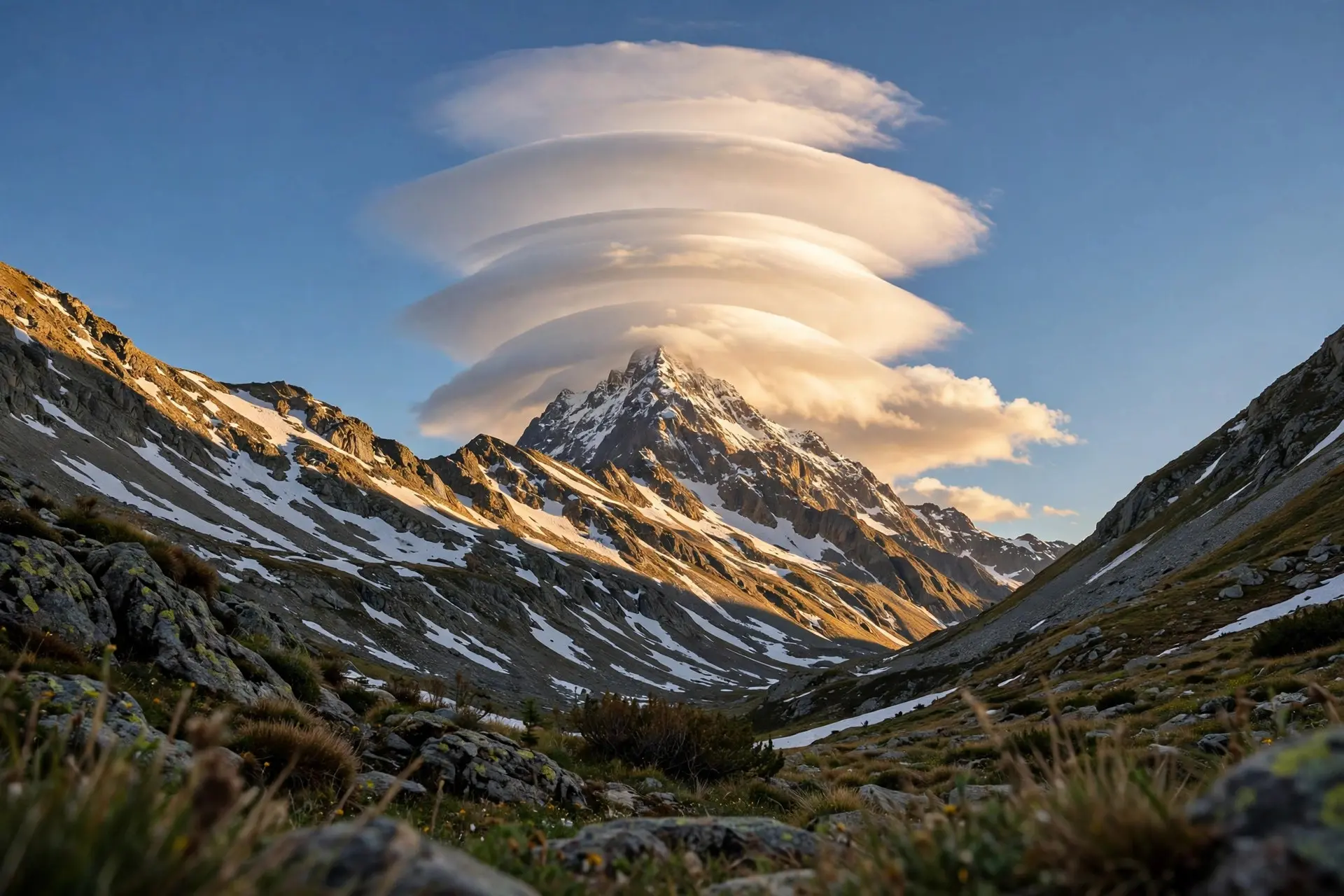
Lenticular clouds are smooth, lens-shaped clouds that form in standing mountain waves. They hover in place, mimic UFOs, and warn pilots of turbulence.
Key takeaways
- Lenticular clouds are smooth, lens-shaped clouds that form downwind of mountains when stable air flows across high ground.
- The name comes from altocumulus lenticularis, Latin for 'like a lens'; their bases sit between 6,500 and 16,500 feet.
- They look stationary, but air rushes through them: vapor condenses at each wave crest and evaporates on the far side.
- The UK Met Office calls them one of the most common explanations for UFO sightings around the world.
- Pilots avoid them because they mark mountain waves with severe turbulence, while glider pilots seek them out for the rising air.
Lenticular clouds are smooth, lens-shaped clouds that form downwind of hills and mountains when stable air blows across high ground. The air sets up standing waves like ripples behind a river boulder, and vapor condenses into a saucer at each wave crest while evaporating on the far side, so the cloud looks parked for hours while the wind rushes straight through it.
- Their bases sit between 6,500 and 16,500 feet (about 2,000 to 5,000 meters), and the name is altocumulus lenticularis, Latin for "like a lens." (Met Office)
- They form when air is stable and winds blow across mountains from a similar direction at different heights through the troposphere. (Met Office)
- Although strong winds may be flowing through them, the clouds hold position because condensation keeps occurring at the wave's crest and evaporation at its downstream edge. (Met Office)
- The Met Office notes they look like the traditional flying saucer shape and are believed to be one of the most common explanations for UFO sightings worldwide. (Met Office)
- They come in three types: altocumulus standing lenticular (ACSL), stratocumulus standing lenticular (SCSL), and cirrocumulus standing lenticular (CCSL), varying in altitude. (Met Office)
- Powered aircraft avoid them because of the turbulence; skilled glider pilots seek them out, reading the lens shape to find rising air. (Met Office)
How does a mountain build a flying saucer?
Step by step, the atmosphere does the sculpting:
- Stable, moist air approaches a mountain. Stability is the key ingredient: the air cannot just keep rising over the summit.
- The airflow is forced up, then sinks back. Past the peak, the air plunges, overshoots, and rebounds, setting up a train of large standing waves downstream, like ripples forming in a river behind an obstruction.
- Rising air cools and condenses. At each wave crest, the lifted air cools below its dew point and water vapor becomes visible droplets: a lens is born.
- Descending air warms and erases. On the far side of the crest, the sinking air warms, the droplets evaporate, and the lens dissolves.
- The pattern repeats at each crest. Several alternating bands of cloud and clear sky can line up in a row, or moist layers can stack into the classic "pile of plates." That continuous make-and-break cycle is why a lenticular cloud can sit over the same ridge for hours in a gale. Nothing is parked; everything is being rebuilt in place, dozens of times over.
What are the three types?
| Type | Full name | Altitude | Character |
|---|---|---|---|
| SCSL | Stratocumulus standing lenticular | Lowest | Broad, low lenses in the lower layer |
| ACSL | Altocumulus standing lenticular | Mid-level (6,500-16,500 ft base) | The classic flying saucer, smooth with clean-cut edges |
| CCSL | Cirrocumulus standing lenticular | High | Thin, wispy ice-crystal lenses near the top of the troposphere |
| The World Meteorological Organization sorts all clouds into 10 basic genera, and lenticulars are most commonly associated with altocumulus. When several moist layers are stacked in the airflow, the wave can produce a pile of lenses one above another, which is what gives some formations their stacked-plate, science-fiction look. |
Why do so many people report them as UFOs?
Because the shape is wrong for a cloud in the popular imagination. Clouds are supposed to be puffy and ragged; a smooth, symmetrical lens with sharp edges hovering motionless over a peak looks manufactured. Add the occasional iridescence on the edges, and a hiker with a phone camera has a genuine mystery on their hands. The Met Office's verdict is blunt: these strange, unnatural-looking clouds are one of the most common explanations for UFO sightings across the world.
The illusion is strongest at dawn and dusk, when low sunlight gilds the lens and the mountain below is already in shadow. Photographers love them; air-traffic controllers do not. Sometimes the lens gets dressed up even further. When the cloud's droplets are very uniform in size, sunlight diffracting around their edges can paint the rim with iridescent pastel colors, a fringe of pink, green, and gold called irisation. It is the same optical trick that colors soap bubbles, scaled up to a mountain. On rare occasions people mistake a strongly iridescent lenticular for something even more exotic, like a polar stratospheric cloud, but those form far higher, in the stratosphere, and only in polar winter. A low, smooth lens over a ridge in ordinary weather is a lenticular, however jewel-toned its edges.
Why do pilots and gliders disagree about them?
A lenticular cloud is a warning flag. It marks a mountain wave, and mountain waves carry severe turbulence plus strong, gusty winds on the lee side of high ground, even when no cloud has formed. The Met Office notes the gusts can hammer one spot while the air a few hundred meters away sits calm. Powered aircraft give the lenses a wide berth. Glider pilots read the same sign as an invitation. The smooth shape of the lens tells them exactly where the air is rising, and a good wave can lift a glider thousands of feet with no engine at all. It takes skill and nerve: the wave's crest is smooth, but the rotor beneath it is violent. For a different kind of wave-shaped cloud, see the Kelvin-Helmholtz breaking waves, and for the basic question of how any cloud stays aloft, why clouds float has the answer. Lenticulars are the rare cloud that looks artificial, behaves like a standing wave, and tells the truth about invisible turbulence, all while sitting perfectly still in a storm of moving air. One more curiosity: lenticulars do not need daylight. The recipe is stable air, a mountain, and moisture, and condensation works the same under a full moon, leaving moonlit lenses over dark ridges. The saucer holds its station until the wind changes its mind. How we made this article: FactSpire researched and drafted it with AI assistance and checked every fact against the sources listed above.
Frequently asked questions
Why do lenticular clouds look like flying saucers?
Because they are built by waves, not wind. Stable air crossing a mountain sets up a train of standing waves downstream, and vapor condenses into a smooth lens at each wave crest, then evaporates as the air descends. The result is a curved, stacked lens with clean edges that happens to match science-fiction's idea of a saucer.
Do lenticular clouds move?
They look parked, but they are not. Strong winds blow straight through them while the cloud stays in place, because condensation keeps forming at the wave's crest and evaporation keeps erasing it at the downstream edge. It is a standing pattern made of moving air, like the ripple behind a boulder in a fast river.
Are lenticular clouds dangerous?
To aircraft, yes. They are the visible sign of mountain waves that carry severe turbulence and strong, gusty winds on the lee side of high ground, so powered aircraft steer clear. Glider pilots take the opposite view: the smooth lens shape marks exactly where the air is rising, and they ride it.
Where can I see lenticular clouds?
Anywhere wind blows across high ground in stable air. In Britain they favor Cumbria, Wales, Scotland, and spots east of the Pennines. Globally they are classic around isolated high peaks, where a symmetrical mountain shapes the airflow into textbook lenses.
Sources
- Lenticular clouds, Met Office
- Deep dive: From mountain waves to mammatus, Met Office
- NWS ABQ - Mountain Wave Study, National Weather Service